Leaflet Distribution Bath
Leaflet Network
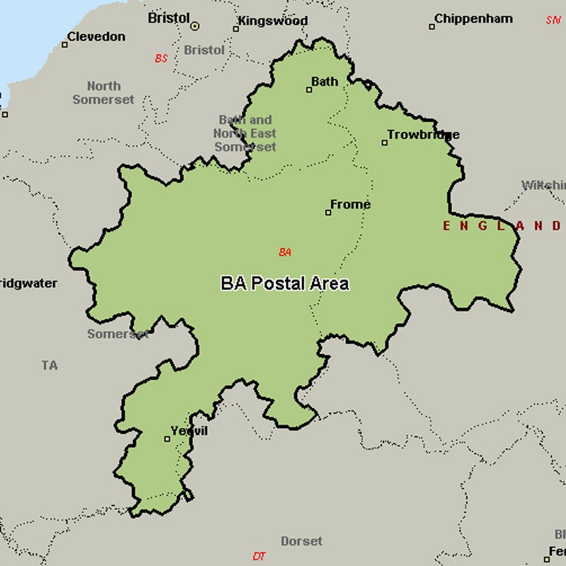
The BA postcode area, also known as the Bath postcode area, covers east Somerset (including Bath, Yeovil, Bruton, Castle Cary, Frome, Glastonbury, Radstock, Shepton Mallet, Street, Templecombe, Wells and Wincanton) and west Wiltshire (including Bradford on Avon, Trowbridge, Warminster and Westbury), plus a very small part of north-west Dorset.
Approximate total number of households in area: 174612
Get in touch with the team directly to arrange the leaflet distribution with them, or alternatively, get in touch with the leaflet network team to arrange this distribution for you. To come through the leaflet network there may be an added fee, but we will make sure to get every angle covered for you. For general enquiries please use the contact page.
| Postcode Sector | Households |
|---|---|
| BA1 1 | 655 |
| BA1 2 | 2662 |
| BA1 3 | 2948 |
| BA1 4 | 2630 |
| BA1 5 | 2170 |
| BA1 6 | 3792 |
| BA1 7 | 2335 |
| BA1 8 | 319 |
| BA1 9 | 172 |
| BA10 0 | 1359 |
| BA11 1 | 2132 |
| BA11 2 | 4448 |
| BA11 3 | 2037 |
| BA11 4 | 2663 |
| BA11 5 | 1127 |
| BA11 6 | 763 |
| BA12 0 | 2296 |
| BA12 6 | 1819 |
| BA12 7 | 1390 |
| BA12 8 | 3693 |
| BA12 9 | 2912 |
| BA13 2 | 181 |
| BA13 3 | 4969 |
| BA13 4 | 2369 |
| BA14 0 | 4939 |
| BA14 6 | 2217 |
| BA14 7 | 4803 |
| BA14 8 | 2051 |
| BA14 9 | 3428 |
| BA15 1 | 3966 |
| BA15 2 | 1734 |
| BA16 0 | 4024 |
| BA16 9 | 1019 |
| BA2 0 | 1882 |
| BA2 1 | 5773 |
| BA2 2 | 4804 |
| BA2 3 | 3414 |
| BA2 4 | 2647 |
| BA2 5 | 3064 |
| BA2 6 | 2957 |
| BA2 7 | 1952 |
| BA2 8 | 3003 |
| BA2 9 | 578 |
| BA20 1 | 1281 |
| BA20 2 | 3459 |
| BA21 3 | 5722 |
| BA21 4 | 3897 |
| BA21 5 | 4127 |
| BA22 7 | 1436 |
| BA22 8 | 2953 |
| BA22 9 | 2344 |
| BA3 2 | 4015 |
| BA3 3 | 4021 |
| BA3 4 | 2744 |
| BA3 5 | 2704 |
| BA4 4 | 1538 |
| BA4 5 | 3389 |
| BA4 6 | 1751 |
| BA5 1 | 2305 |
| BA5 2 | 3401 |
| BA5 3 | 1897 |
| BA6 8 | 2703 |
| BA6 9 | 2684 |
| BA7 7 | 1615 |
| BA8 0 | 1639 |
| BA9 8 | 597 |
| BA9 9 | 2294 |