This is the section of the United Kingdom, Scotland and consists of 14 Postal areas, which are all available for your flyers to be delivered to. View the Postal areas below, where you can follow and enquire about leaflet distribution with our team in the area.
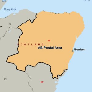
The AB postcode area, also known as the Aberdeen postcode area, covers the Aberdeen council area (including the city of Aberdeen, Milltimber and Peterculter), Aberdeenshire (including Banff, Macduff, Fraserburgh, Peterhead, Ellon, Turriff, Huntly, Insch, Inverurie, Westhill, Alford, Strathdon, Ballater, Aboyne, Banchory, Laurencekirk and Stonehaven) and east Moray (including Buckie, Keith, Aberlour and Ballindalloch).
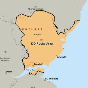
The DD postcode area, also known as the Dundee postcode area, covers Dundee and Angus (including Forfar, Arbroath, Brechin, Carnoustie, Kirriemuir and Montrose), plus part of north-east Fife (including Newport-on-Tay and Tayport) and small parts of Perth and Kinross and Aberdeenshire.
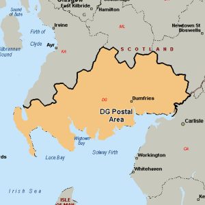
The DG postcode area, also known as the Dumfries and Galloway postcode area, covers most of Dumfries and Galloway, including Dumfries, Annan, Canonbie, Castle Douglas, Dalbeattie, Gretna, Kirkcudbright, Langholm, Lockerbie, Moffat, Newton Stewart, Sanquhar, Stranraer and Thornhill. The DG16 district also extends across the border into Cumbria, England.
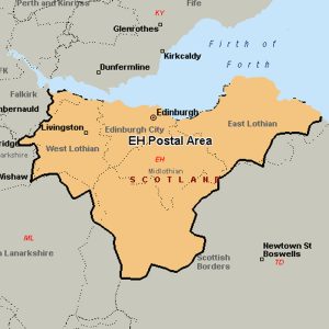
The EH postcode area, also known as the Edinburgh postcode area, covers Armadale, Balerno, Bathgate, Bo’ness, Bonnyrigg, Broxburn, Currie, Dalkeith, Dunbar, East Linton, Edinburgh, Gorebridge, Gullane, Haddington, Heriot, Humbie, Innerleithen, Juniper Green, Kirkliston, Kirknewton, Lasswade, Linlithgow, Livingston, Loanhead, Longniddry, Musselburgh, Newbridge, North Berwick, Pathhead, Peebles, Penicuik, Prestonpans, Rosewell, Roslin, South Queensferry, Tranent, Walkerburn, West Calder and West Linton in Scotland.
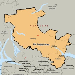
The FK postcode area, also known as the Falkirk postcode area, covers most of the Falkirk council area (including Falkirk itself, Grangemouth, Larbert, Denny and Bonnybridge), most of the Stirling council area (including Stirling itself, Dunblane, Doune, Callander, Lochearnhead, Crianlarich and Killin) and Clackmannanshire (including Alloa, Clackmannan, Menstrie, Alva, Tillicoultry and Dollar), plus small parts of Fife, Perth and Kinross, and Argyll and Bute.
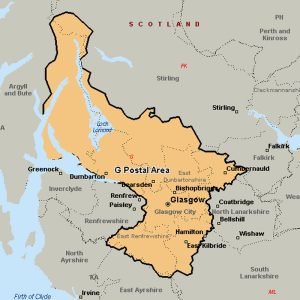
The G postcode area, also known as the Glasgow postcode area, is primarily centered on Glasgow itself, and West Dunbartonshire (including Dumbarton, Clydebank and Alexandria), plus parts of the council areas of Argyll and Bute (including Arrochar and Helensburgh), East Dunbartonshire, North Lanarkshire, South Lanarkshire, East Renfrewshire and Stirling.
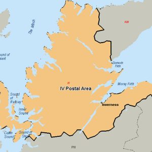
The IV postcode area, also known as the Inverness postcode area, covers Achnasheen, Alness, Avoch, Beauly, Bonar Bridge, Cromarty, Dingwall, Dornoch, Elgin, Fochabers, Forres, Fortrose, Gairloch, Garve, Invergordon, Inverness, Isle of Skye, Kyle, Lairg, Lossiemouth, Muir of Ord, Munlochy, Nairn, Plockton, Portree, Rogart, Strathcarron, Strathpeffer, Strome Ferry, Tain and Ullapool in north Scotland.
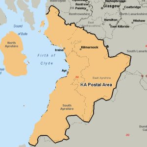
The KA postcode area, also known as the Kilmarnock postcode area, covers East Ayrshire, North Ayrshire (including the Isle of Arran) and South Ayrshire.
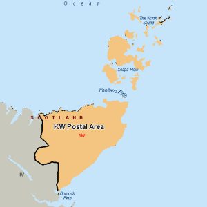
The KW postcode area, or Kirkwall postcode area, covers Caithness (including Wick, Thurso, Halkirk, Berriedale, Dunbeath, Latheron and Lybster), east Sutherland (including Golspie, Brora, Helmsdale, Kinbrace and Forsinard) and the Orkney Islands.
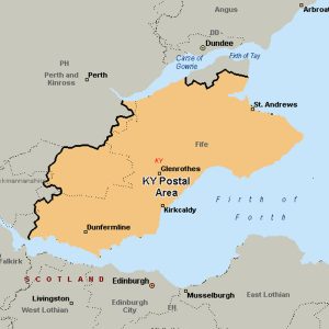
The KY postcode area, also known as the Kirkcaldy postcode area, covers most of Fife (including Kirkcaldy, Dunfermline, Glenrothes, St Andrews, Anstruther, Burntisland, Cowdenbeath, Cupar, Inverkeithing, Kelty, Leven and Lochgelly), plus the far south of Perth and Kinross (including Kinross itself).
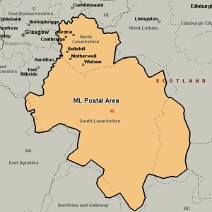
The ML postcode area, also known as the Motherwell postcode area, covers most of North Lanarkshire (including Motherwell, Wishaw, Bellshill, Coatbridge, Airdrie and Shotts) and South Lanarkshire (including Hamilton, Carluke, Larkhall, Strathaven, Lanark and Biggar), plus very small parts of West Lothian, the Scottish Borders and Dumfries and Galloway.
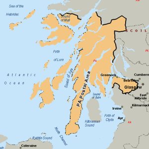
The PA postcode area, also known as the Paisley postcode area, covers Renfrewshire (including Paisley, Renfrew, Johnstone, Bishopton, Erskine, Bridge of Weir and Lochwinnoch), Inverclyde (including Greenock, Port Glasgow, Gourock, Kilmacolm and Wemyss Bay) and most of Argyll and Bute (including Oban, Lochgilphead, Tarbert, Campbeltown, Appin, Taynuilt, Bridge of Orchy, Dalmally, Inveraray, Cairndow, Colintraive, Dunoon, Tighnabruaich, and the Isles of Mull, Iona, Coll, Tiree, Jura, Colonsay, Islay, Gigha and Bute), plus small parts of North Ayrshire (including Skelmorlie) and Highland.
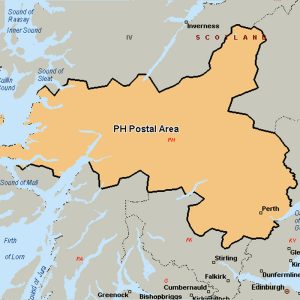
The PH postcode area, also known as the Perth postcode area, covers Aberfeldy, Acharacle, Arisaig, Auchterarder, Aviemore, Ballachulish, Blairgowrie, Boat of Garten, Carrbridge, Corrour, Crieff, Dalwhinnie, Dunkeld, Fort Augustus, Fort William, Glenfinnan, Grantown-on-Spey, Invergarry, Isle of Canna, Isle of Eigg, Isle of Rum, Kingussie, Kinlochleven, Lochailort, Mallaig, Nethy Bridge, Newtonmore, Perth, Pitlochry, Roy Bridge and Spean Bridge in Scotland.
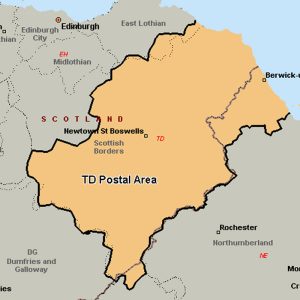
The TD postcode area, also known as the Galashiels postcode area, covers most of the Scottish Borders council area (including Galashiels, Lauder, Gordon, Earlston, Kelso, Melrose, Selkirk, Jedburgh, Hawick, Newcastleton, Duns, Coldstream, Cockburnspath and Eyemouth) and the northernmost part of Northumberland (including Berwick-upon-Tweed, Cornhill-on-Tweed and Mindrum), plus a part of south-eastern East Lothian and a very small part of Cumbria.