This is the section of the United Kingdom, we label England South East and consists of 31 Postal areas, which are all available for your flyers to be delivered to. View the Postal areas below, where you can follow and enquire about leaflet distribution with our team in the area.
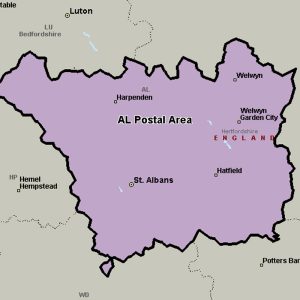
The AL postcode area, also known as the St Albans postcode area, covers central Hertfordshire, including St Albans, Harpenden, Welwyn, Welwyn Garden City and Hatfield.
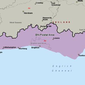
The BN postcode area, also known as the Brighton postcode area, covers southwestern East Sussex (including Brighton, Hove, Eastbourne, Lewes, Hailsham, Newhaven, Peacehaven, Pevensey, Polegate and Seaford) and southeastern West Sussex (including Worthing, Littlehampton, Arundel, Hassocks, Henfield, Lancing, Shoreham-by-Sea and Steyning).
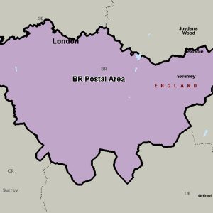
The BR postcode area, also known as the Bromley postcode area, covers part of south-eastern Greater London, as well as a small part of north-west Kent.
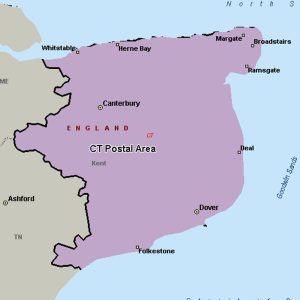
The CT postcode area, also known as the Canterbury postcode area, covers much of east Kent, including Canterbury, Dover, Folkestone, Birchington, Broadstairs, Deal, Herne Bay, Hythe, Margate, Ramsgate, Sandwich, Westgate-on-Sea and Whitstable.
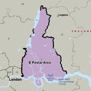
The E (Eastern) postcode area, also known as the London E postcode area, is the part of the London post town covering much of east London. It borders the N postcode area to the west, both north of the tidal Thames.
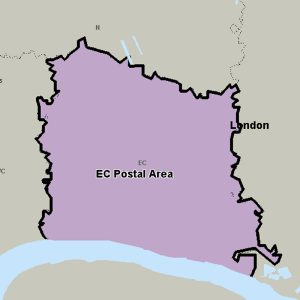
The EC (Eastern Central) postcode area, also known as the London EC postal area, is a group of postcode districts in central London. It includes almost all of the City of London and parts of the London boroughs of Islington, Camden, Hackney, Tower Hamlets and Westminster.
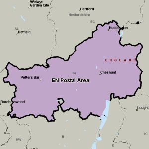
The EN postcode area, also known as the Enfield postcode area, covers parts of northern Greater London (including Enfield and Barnet), southern Hertfordshire (including Potters Bar, Waltham Cross, Broxbourne and Hoddesdon) and western Essex (including Waltham Abbey).
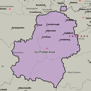
The GU postcode area, also known as the Guildford postcode area, covers west Surrey (including Guildford, Woking, Godalming, Cranleigh, Farnham, Camberley, Lightwater, Bagshot, Windlesham, Virginia Water, Hindhead and Haslemere), north-east Hampshire (including Aldershot, Farnborough, Fleet, Yateley, Petersfield, Alton, Bordon, Liphook and Liss), northwestern West Sussex (including Petworth and Midhurst) and a small part of south-east Berkshire (including Sandhurst).
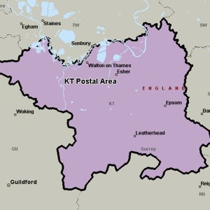
The KT postcode area, also known as the Kingston upon Thames postcode area, covers boroughs in south-west Greater London and several boroughs in north-east Surrey.
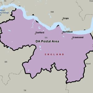
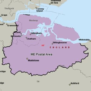
The ME postcode area, also known as the Rochester postcode area, covers north central Kent, including the Medway unitary authority and the borough of Swale, plus parts of the boroughs of Maidstone, Tonbridge and Malling, and Gravesham.
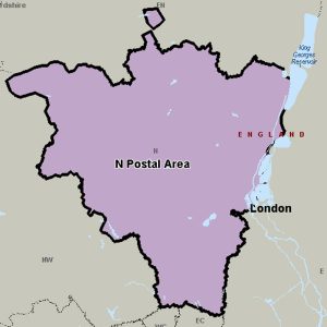
The N (Northern) postcode area, also known as the London N postcode area, is the part of the London post town covering part of North London. The area covers parts of the London Boroughs of Hackney, Islington, Camden, Barnet, Haringey and Enfield.
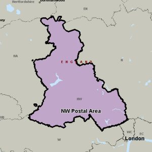
The NW (North Western) postcode area, also known as the London NW postcode area, is a group of 13 postcode districts covering around 13,895 live postcodes within part of northwest London.
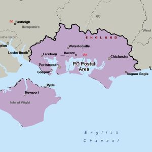
The PO postcode area, also known as the Portsmouth postcode area, covers south-east Hampshire (including Portsmouth, Southsea, Havant, Waterlooville, Lee-on-the-Solent, Gosport, Fareham, Rowland’s Castle, Emsworth and Hayling Island), southwestern West Sussex (including Chichester and Bognor Regis) and the Isle of Wight.
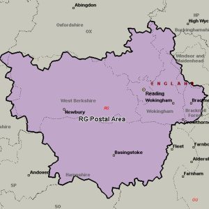
The RG postcode area, also known as the Reading postcode area, covers west and central Berkshire (including Reading, Bracknell, Crowthorne, Hungerford, Newbury, Thatcham and Wokingham) and north Hampshire (including Basingstoke, Hook, Tadley and Whitchurch), plus a small part of south-east Oxfordshire (including Henley-on-Thames) and very small parts of Buckinghamshire and Wiltshire.
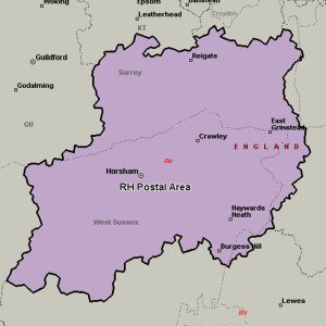
The RH postcode area, also known as the Redhill postcode area, covers east Surrey (including Redhill, Reigate, Betchworth, Dorking, Lingfield, Horley, Oxted and Godstone) and northeastern West Sussex (including Crawley, Gatwick, Haywards Heath, Billingshurst, East Grinstead, Burgess Hill, Horsham and Pulborough) plus small parts of northwestern East Sussex (including Forest Row).
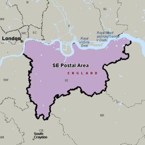
The SE (South Eastern) postcode area covers a broad radial swathe of the south-east of the London post town from the Albert Embankment to West Heath and the nearest edges of Sidcup and Selhurst.
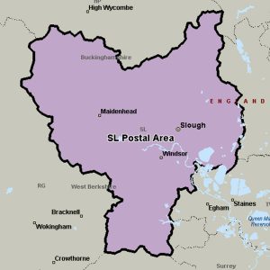
The SL postcode area, also known as the Slough postcode area, covers east Berkshire (including Slough, Maidenhead, Windsor and Ascot) and south Buckinghamshire (including Iver, Gerrards Cross, Marlow and Bourne End), plus a very small part of south-west Hertfordshire.
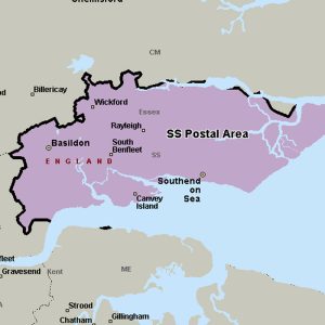
The SS postcode area, also known as the Southend-on-Sea postcode area, covers south-east Essex, including Southend-on-Sea, Basildon, Benfleet, Canvey Island, Hockley, Leigh-on-Sea, Rayleigh, Rochford, Stanford-le-Hope, Westcliff-on-Sea and Wickford.
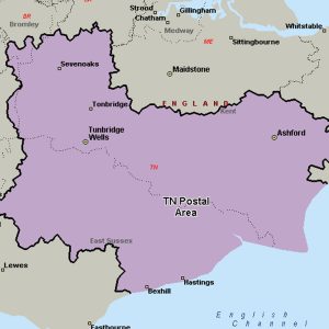
The TN postcode area, also known as the Tunbridge Wells postcode area, covers south Kent (including Royal Tunbridge Wells, Tonbridge, Ashford, Sevenoaks, Cranbrook, Edenbridge, New Romney, Romney Marsh and Tenterden) and northern and eastern East Sussex (including Hastings, Battle, Bexhill-on-Sea, Crowborough, Etchingham, Hartfield, Heathfield, Mayfield, Robertsbridge, Rye, St Leonards-on-Sea, Uckfield, Wadhurst and Winchelsea), plus very small parts of Surrey and the London Borough of Bromley.
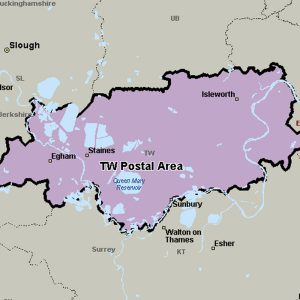
The TW postcode area, also known as the Twickenham postcode area, covers parts of south-west London and north-west Surrey, plus a very small part of Berkshire.
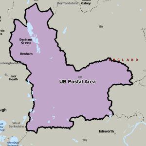
The UB postcode area, also known as the Uxbridge postcode area, covers parts of western and north-western Greater London, plus a very small part of Buckinghamshire.
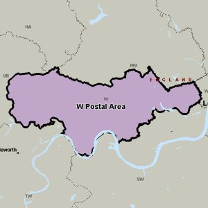
The W (Western and Paddington) postcode area, also known as the London W postcode area, is a group of postcode districts covering part of central and part of West London, England.
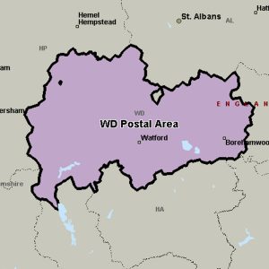
The WD postcode area, also known as the Watford postcode area, covers south-west Hertfordshire (including Watford, Rickmansworth, Borehamwood, Kings Langley, Abbots Langley, Bushey and Radlett), plus very small parts of Buckinghamshire and the London Borough of Hillingdon.