Leaflet Distribution Redhill
Leaflet Network
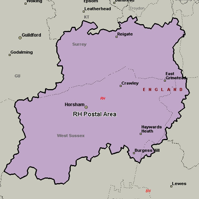
The RH postcode area, also known as the Redhill postcode area, covers east Surrey (including Redhill, Reigate, Betchworth, Dorking, Lingfield, Horley, Oxted and Godstone) and northeastern West Sussex (including Crawley, Gatwick, Haywards Heath, Billingshurst, East Grinstead, Burgess Hill, Horsham and Pulborough) plus small parts of northwestern East Sussex (including Forest Row).
Approximate total number of households in area: 207873
Get in touch with the team directly to arrange the leaflet distribution with them, or alternatively, get in touch with the leaflet network team to arrange this distribution for you. To come through the leaflet network there may be an added fee, but we will make sure to get every angle covered for you. For general enquiries please use the contact page.
| Postcode Sector | Households |
|---|---|
| RH1 1 | 1822 |
| RH1 2 | 2669 |
| RH1 3 | 3521 |
| RH1 4 | 2558 |
| RH1 5 | 3356 |
| RH1 6 | 4219 |
| RH10 1 | 2297 |
| RH10 3 | 4622 |
| RH10 4 | 2929 |
| RH10 5 | 2512 |
| RH10 6 | 4013 |
| RH10 7 | 6193 |
| RH10 8 | 2320 |
| RH10 9 | 79 |
| RH11 0 | 3786 |
| RH11 6 | 974 |
| RH11 7 | 4588 |
| RH11 8 | 5846 |
| RH11 9 | 5010 |
| RH12 1 | 2833 |
| RH12 2 | 3290 |
| RH12 3 | 3128 |
| RH12 4 | 4232 |
| RH12 5 | 3946 |
| RH13 0 | 1389 |
| RH13 5 | 3854 |
| RH13 6 | 3377 |
| RH13 8 | 2449 |
| RH13 9 | 3429 |
| RH14 0 | 2272 |
| RH14 9 | 3086 |
| RH15 0 | 4181 |
| RH15 8 | 4822 |
| RH15 9 | 3457 |
| RH16 1 | 2888 |
| RH16 2 | 3020 |
| RH16 3 | 4371 |
| RH16 4 | 3307 |
| RH17 5 | 2451 |
| RH17 6 | 2181 |
| RH17 7 | 2458 |
| RH18 5 | 1801 |
| RH19 1 | 2831 |
| RH19 2 | 2756 |
| RH19 3 | 4310 |
| RH19 4 | 3104 |
| RH2 0 | 2807 |
| RH2 7 | 3079 |
| RH2 8 | 2825 |
| RH2 9 | 1827 |
| RH20 1 | 1937 |
| RH20 2 | 2997 |
| RH20 3 | 2390 |
| RH20 4 | 2753 |
| RH3 7 | 1853 |
| RH4 1 | 2363 |
| RH4 2 | 2236 |
| RH4 3 | 2256 |
| RH5 4 | 3033 |
| RH5 5 | 2084 |
| RH5 6 | 1493 |
| RH6 0 | 957 |
| RH6 7 | 2346 |
| RH6 8 | 3815 |
| RH6 9 | 4688 |
| RH7 6 | 3268 |
| RH8 0 | 3706 |
| RH8 9 | 2391 |
| RH9 8 | 2232 |