This is the section of the United Kingdom, we label England Mid and consists of 26 Postal areas, which are all available for your flyers to be delivered to. View the Postal areas below, where you can follow and enquire about leaflet distribution with our team in the area.
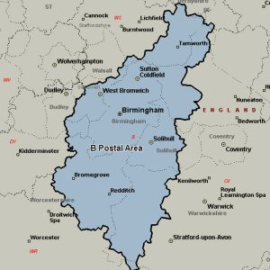
The B postcode area, also known as the Birmingham postcode area, covers the central portion of the West Midlands (including Birmingham, West Bromwich, Sutton Coldfield, Smethwick, Solihull, Halesowen, Cradley Heath, Oldbury and Rowley Regis), plus northeast Worcestershire (including Bromsgrove and Redditch), north and west Warwickshire (including Alcester, Studley and Henley-in-Arden), and part of southeast Staffordshire (including Tamworth) and a very small part of Leicestershire.
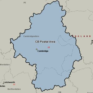
The CB postcode area, also known as the Cambridge postcode area, covers much of south and east Cambridgeshire (including Cambridge and Ely), plus parts of west Suffolk (including Newmarket and Haverhill) and north-west Essex (including Saffron Walden) and a very small part of Norfolk.
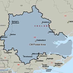
The CM postcode area, also known as the Chelmsford postcode area, covers central Essex (including Chelmsford, Harlow, Brentwood, Billericay, Braintree, Burnham-on-Crouch, Dunmow, Epping, Ingatestone, Maldon, Ongar, Southminster, Stansted and Witham), plus a small part of east Hertfordshire (including Bishop’s Stortford and Sawbridgeworth) and a very small part of the London Borough of Havering.
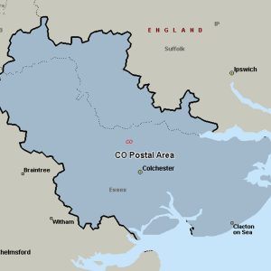
The CO postcode area, also known as the Colchester postcode area, covers northeast Essex (including Colchester, Bures, Clacton-on-Sea, Frinton-on-Sea, Halstead, Harwich, Manningtree and Walton-on-the-Naze) and a small part of south Suffolk (including Sudbury). The main sorting office is in Colchester.
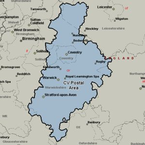
The CV postcode area, also known as the Coventry postcode area covers the eastern part of the West Midlands (including Coventry), most of Warwickshire (including Atherstone, Bedworth, Kenilworth, Leamington Spa, Nuneaton, Rugby, Shipston-on-Stour, Southam, Stratford-upon-Avon and Warwick), a part of west Leicestershire and a very small part of Northamptonshire.
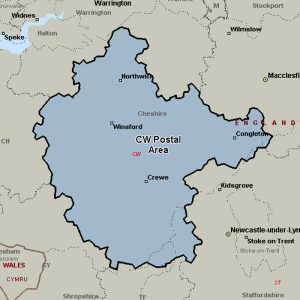
The CW postcode area, also known as the Crewe postcode area, covers much of Cheshire, including Crewe, Northwich, Congleton, Middlewich, Nantwich, Sandbach, Tarporley and Winsford, plus very small parts of Staffordshire and Shropshire.
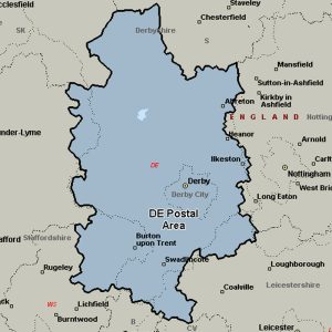
The DE postcode area, also known as the Derby postcode area, covers south and central Derbyshire (including Derby, Alfreton, Ashbourne, Bakewell, Belper, Heanor, Ilkeston, Matlock, Ripley and Swadlincote), parts of east Staffordshire (including Burton upon Trent) and north-west Leicestershire, and very small parts of Nottinghamshire.
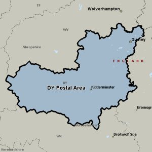
The DY postcode area, also known as the Dudley postcode area, covers the south-western part of the West Midlands (including Dudley, Tipton, Brierley Hill, Stourbridge and Kingswinford) and north Worcestershire (including Kidderminster, Bewdley and Stourport-on-Severn), plus the south-westernmost part of Staffordshire and a small part of south-east Shropshire.
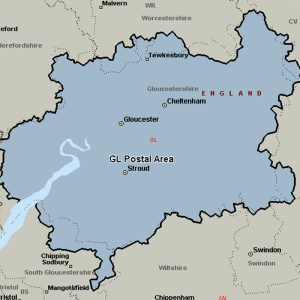
The GL postcode area, also known as the Gloucester postcode area, covers Badminton, Berkeley, Blakeney, Cheltenham, Chipping Campden, Cinderford, Cirencester, Coleford, Drybrook, Dursley, Dymock, Fairford, Gloucester, Lechlade, Longhope, Lydbrook, Lydney, Mitcheldean, Moreton-in-Marsh, Newent, Newnham, Ruardean, Stonehouse, Stroud, Tetbury, Tewkesbury, Westbury-on-Severn and Wotton-under-Edge and a very small parts of Herefordshire, Monmouthshire, Oxfordshire, Warwickshire, Wiltshire and Worcestershire.
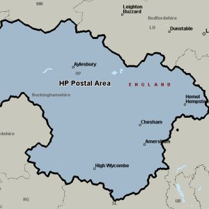
The HP postcode area, also known as the Hemel Hempstead postcode area, covers north-west Hertfordshire (including Hemel Hempstead, Berkhamsted and Tring) and central Buckinghamshire (including Aylesbury, High Wycombe, Beaconsfield, Amersham, Chalfont St Giles, Chesham, Great Missenden and Princes Risborough).
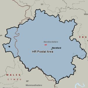
The HR postcode area, also known as the Hereford postcode area, covers most of Herefordshire, including Hereford, Bromyard, Kington, Ledbury, Leominster and Ross-on-Wye, while the HR2, HR3 and HR5 districts extend across the border to cover a small part of Powys.
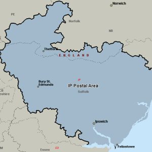
The IP postcode area, also known as the Ipswich postcode area, covers most of Suffolk (including Ipswich, Bury St Edmunds, Aldeburgh, Brandon, Eye, Felixstowe, Halesworth, Leiston, Saxmundham, Southwold, Stowmarket and Woodbridge), plus southern Norfolk (including Thetford, Diss and Harleston) and a very small part of Cambridgeshire.
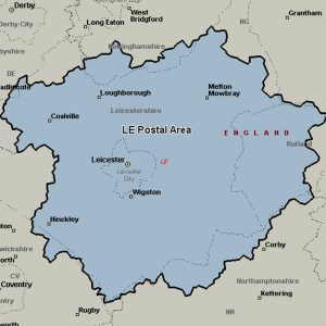
The LE postcode area, also known as the Leicester postcode area, covers most of Leicestershire (including Leicester, Loughborough, Hinckley, Melton Mowbray, Coalville, Market Harborough, Ashby de la Zouch, Lutterworth, Wigston, Markfield and Ibstock) and Rutland (including Oakham), plus small parts of south Nottinghamshire and north Northamptonshire, and very small parts of Derbyshire and Warwickshire.
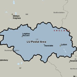
The LU postcode area, also known as the Luton postcode area, covers south Bedfordshire (including Luton, Dunstable and Leighton Buzzard), plus small parts of north Hertfordshire and east Buckinghamshire.
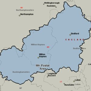
The MK postcode area, also known as the Milton Keynes postcode area, covers north Buckinghamshire (including Milton Keynes, Buckingham, Newport Pagnell and Olney), west and north Bedfordshire (including Bedford) and very small parts of Northamptonshire, Oxfordshire and Cambridgeshire.
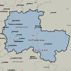
The NG postcode area, also known as the Nottingham postcode area, covers central Nottinghamshire (including Nottingham, Mansfield, Sutton-in-Ashfield, Newark-on-Trent and Southwell), parts of south-west Lincolnshire (including Grantham and Sleaford) and small parts of Derbyshire and Leicestershire.
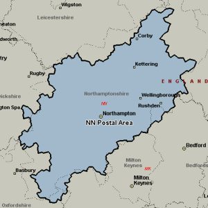
The NN postcode area, also known as the Northampton postcode area, covers most of Northamptonshire (including Northampton, Kettering, Wellingborough, Corby, Brackley, Daventry, Rushden and Towcester), plus very small parts of Bedfordshire, Buckinghamshire, Leicestershire, Oxfordshire and Warwickshire.
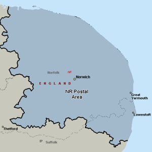
The NR postcode area, also known as the Norwich postcode area, covers central and eastern Norfolk (including Norwich, Great Yarmouth, Attleborough, Wymondham, Dereham, Fakenham, Walsingham, Wells-next-the-Sea, Melton Constable, Holt, Sheringham, Cromer and North Walsham) and part of north-east Suffolk (including Lowestoft, Beccles and Bungay).
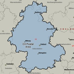
The OX postcode area, also known as the Oxford postcode area, covers most of Oxfordshire (including Oxford, Banbury, Abingdon, Bicester, Witney, Didcot, Carterton, Kidlington, Thame, Wantage, Wallingford, Chipping Norton, Chinnor, Woodstock, Watlington, Bampton and Burford), plus very small parts of Northamptonshire, Buckinghamshire, Berkshire, Gloucestershire and Warwickshire.
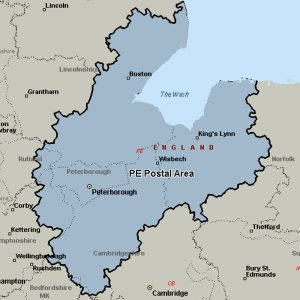
The PE postcode area, also known as the Peterborough postcode area, covers most of Cambridgeshire (including Peterborough, Huntingdon, Chatteris, St. Neots, St Ives, March and Wisbech), much of south Lincolnshire (including Bourne, Stamford, Spalding, Boston, Skegness and Spilsby) and west Norfolk (including King’s Lynn, Hunstanton, Sandringham, Swaffham and Downham Market), plus parts of east Northamptonshire and very small parts of Bedfordshire and Rutland.
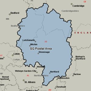
The SG postcode area, also known as the Stevenage postcode area, covers north Hertfordshire (including Stevenage, Baldock, Buntingford, Hertford, Hitchin, Knebworth, Letchworth, Much Hadham, Royston and Ware) and east Bedfordshire (including Arlesey, Biggleswade, Henlow, Sandy and Shefford), plus a small part of south-west Cambridgeshire and a very small part of Essex.
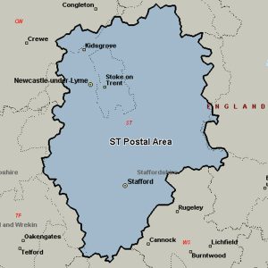
The ST postcode area, also known as the Stoke-on-Trent postcode area, covers much of north and central Staffordshire (including Stoke-on-Trent, Stafford, Leek, Newcastle-under-Lyme, Stone and Uttoxeter), plus very small parts of Cheshire and Derbyshire.
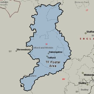
The TF postcode area, also known as the Telford postcode area, covers north-east Shropshire, including Telford, Broseley, Market Drayton, Much Wenlock, Newport and Shifnal, plus a small part of west Staffordshire.
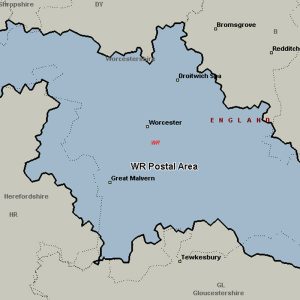
The WR postcode area, also known as the Worcester postcode area, covers central and southern Worcestershire (including Worcester, Broadway, Droitwich, Evesham, Malvern, Pershore and Tenbury Wells), plus very small parts of Herefordshire, Shropshire, Warwickshire and Gloucestershire.
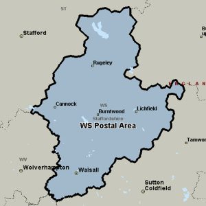
The WS postcode area, also known as the Walsall postcode area, covers the northern part of the West Midlands (including Walsall and Wednesbury) and much of south-east Staffordshire (including Lichfield, Cannock, Burntwood and Rugeley).
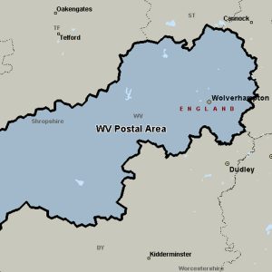
The WV postcode area, also known as the Wolverhampton postcode area, covers Wolverhampton, Willenhall and Bilston in the West Midlands, plus parts of south-west Staffordshire and south-east Shropshire (including Bridgnorth).