Leaflet Distribution Derby
Leaflet Network
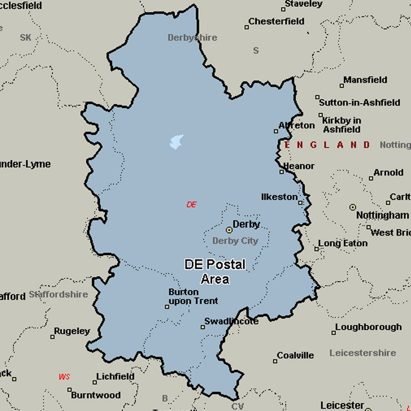
The DE postcode area, also known as the Derby postcode area, covers south and central Derbyshire (including Derby, Alfreton, Ashbourne, Bakewell, Belper, Heanor, Ilkeston, Matlock, Ripley and Swadlincote), parts of east Staffordshire (including Burton upon Trent) and north-west Leicestershire, and very small parts of Nottinghamshire.
Approximate total number of households in area: 282609
Get in touch with the team directly to arrange the leaflet distribution with them, or alternatively, get in touch with the leaflet network team to arrange this distribution for you. To come through the leaflet network there may be an added fee, but we will make sure to get every angle covered for you. For general enquiries please use the contact page.
| Postcode Sector | Households |
|---|---|
| DE1 1 | 2254 |
| DE1 2 | 1110 |
| DE1 3 | 2831 |
| DE11 0 | 5792 |
| DE11 7 | 3588 |
| DE11 8 | 1742 |
| DE11 9 | 4346 |
| DE12 6 | 3035 |
| DE12 7 | 3470 |
| DE12 8 | 1418 |
| DE13 0 | 7041 |
| DE13 7 | 1592 |
| DE13 8 | 2962 |
| DE13 9 | 3782 |
| DE14 1 | 915 |
| DE14 2 | 4449 |
| DE14 3 | 5051 |
| DE15 0 | 4050 |
| DE15 9 | 5807 |
| DE21 2 | 4120 |
| DE21 4 | 5465 |
| DE21 5 | 1412 |
| DE21 6 | 7607 |
| DE21 7 | 5358 |
| DE22 1 | 2407 |
| DE22 2 | 5893 |
| DE22 3 | 7077 |
| DE22 4 | 3265 |
| DE22 5 | 394 |
| DE23 1 | 3504 |
| DE23 2 | 1344 |
| DE23 3 | 1953 |
| DE23 4 | 840 |
| DE23 6 | 6370 |
| DE23 8 | 6978 |
| DE24 0 | 7250 |
| DE24 3 | 2606 |
| DE24 5 | 382 |
| DE24 8 | 6622 |
| DE24 9 | 5738 |
| DE3 0 | 3175 |
| DE3 9 | 3505 |
| DE4 2 | 3960 |
| DE4 3 | 5386 |
| DE4 4 | 2931 |
| DE4 5 | 2597 |
| DE45 1 | 4062 |
| DE5 3 | 5651 |
| DE5 8 | 1537 |
| DE5 9 | 2052 |
| DE55 1 | 3174 |
| DE55 2 | 3093 |
| DE55 3 | 1303 |
| DE55 4 | 3468 |
| DE55 5 | 3323 |
| DE55 6 | 3042 |
| DE55 7 | 4222 |
| DE56 0 | 4855 |
| DE56 1 | 5671 |
| DE56 2 | 3493 |
| DE56 4 | 2211 |
| DE6 1 | 4183 |
| DE6 2 | 1894 |
| DE6 3 | 1516 |
| DE6 4 | 311 |
| DE6 5 | 1476 |
| DE65 5 | 3183 |
| DE65 6 | 4119 |
| DE7 4 | 5077 |
| DE7 5 | 4203 |
| DE7 6 | 4616 |
| DE7 8 | 6157 |
| DE7 9 | 1236 |
| DE72 2 | 1489 |
| DE72 3 | 6773 |
| DE74 2 | 4524 |
| DE75 7 | 7321 |